Friday, May 17, 2013

US Spent More on 2012's Extreme Weather Cleanup than on Schools or Roads - U.S. taxpayers paid nearly $100 billion responding to damages caused by last year's extreme weather events associated with climate change, about $1,100 per taxpayer, according to an analysis by the Natural Resources Defense Council. That means that federal spending to deal with extreme weather far exceeded total spending aimed at solving the problem. In fact, it was eight times the EPA's total budget and eight times the total spending on energy.
Extreme Weather Drove More Than 30 Million People from Their Homes in 2012 - Millions of people were displaced from their homes due to flooding.
Ohio had at least 75 RECORD-BREAKING EXTREME WEATHER EVENTS in 2012. Nationally, 3,527 monthly weather records for heat, rain and snow were broken by extreme weather events, according to an updated review.
160 RECORD-BREAKING EXTREME WEATHER EVENTS in 2012 in Michigan.

**Do your little bit of good where you are:
it's the little bits of good together that overwhelm the world.**
Desmond Tutu


LARGEST QUAKES -

Live Seismograms - Worldwide (update every 30 minutes)

This morning -
None 5.0 or higher.

Yesterday -
5/16/13 -
5.0 WEST CHILE RISE
5.3 SOUTH SANDWICH ISLANDS REGION
5.1 SOUTH OF FIJI ISLANDS
5.0 CARIBBEAN SEA
5.7 SOUTHERN MID-ATLANTIC RIDGE
5.0 WESTERN XIZANG
5.1 WESTERN XIZANG
5.0 SOUTH OF AFRICA

VOLCANOES -
Volcano Webcams

Remote Alaska volcano continues to erupt with lava fountains, ash plumes. Onsite seismic instruments are picking up constant tremors from the eruption at Pavlof, located about 625 miles southwest of Anchorage. Residents of Cold Bay, 37 miles away, have reported seeing a glow from the summit. Steam and ash clouds are occasionally rising to 20,000 feet.

TROPICAL STORMS -

In the Indian Ocean -
Tropical Cyclone Mahasen was located approximately 53 nm southeastward of Dhaka, Bangladesh. The final advisory has been issued on this system.

In the Eastern Pacific -
Tropical storm Alvin was located about about 770 mi [1240 km] SW of Manzanillo, Mexico. Alvin is in a hostile environment. Little change in strength is forecast during the next 48 hours, but Alvin could degenerate into a trough of low pressure at any time.

Mahasen - Bangladesh rides out the weakened storm. Cyclone Mahasen weakened Thursday afternoon into a tropical storm and then dissipated, causing far less damage than had been feared as it passed over Bangladesh and spared Burma almost entirely. Category 1 Mahasen struck the southern coast of Bangladesh on Thursday, lashing remote fishing villages with heavy rain and fierce winds that flattened mud and straw huts, killing 12 people. Cyclone-induced rains have had much of the Bangladesh capital city knee-deep in water since Thursday morning.

SEVERE RAIN STORMS, FLOODING, LANDSLIDES -

Three weeks of extreme weather compels emergency relief from Maldives' government - Maldivian government authorities are providing emergency services and relief funds to island communities battered by three weeks of “extreme weather”. The National Disaster Management Centre issued a statement May 15 urging island and atoll councils to report any damage caused by the “harsh weather” as soon as possible.
Flooding due to three weeks of severe weather and heavy rain has damaged households, sewerage systems, as well as caused extensive agricultural destruction. Food shortages on some islands have resulted from agricultural damage and the disruption of transportation and supply networks due to bad weather. “All islands import food from Male’, however the seas have been so rough [supply] boats are still in Male’ and unable to reach the islands... they will try to send [food supplies] somehow.” Normally, supply boats travel between the atolls at least twice a week. “For the time being there is no emergency. If an island completely runs out of food, the MNDF is always on board [collaborating] with STO and NDMC, and will send vessels.”
The President met with officials from the Maldives Police Service, the Maldives National Defence Force, the NDMC, and other high-ranking government officials to discuss damages sustained and relief counter measures being taken nationwide. Meanwhile, the MNDF and police have issued precautionary warnings to the public due to the severe weather conditions. The Coast Guard issued a request that “all travelers to take necessary precautionary measures before setting on their journeys due to the severe weather with heavy rain and thunderstorms… particularly in the northern and southern regions of the Maldives.” They recommended travelers test communications sets and obtain updated weather forecasts before embarking on any journeys.
The Coast Guard further stated that average wind speeds of 15-25 miles per hour (mph) in the southern atolls and 7-17 mph are expected in the northern atolls, while wind gusts during thunderstorms will reach 40-50 mph. Additionally, the police issued an SMS bulletin today also warning the public to “take precautionary measures due to the bad weather”. A “white bulletin” was also issued by the Maldives Meteorological Service, warning that the central atolls can expect average winds speeds of 23-30 mph.
Thus far damage assessment reports have been submitted by 12 islands from seven atolls – Shaviyani, Meemu, Dhaalu, Thaa, Laamu, Fuvahmulah, and Addu City – representing regions from the far north to the far south of the Maldives. Other islands have reported storm-related damage directly to the media or have spoken with the NDMC, but have yet to official report these issues to the centre.

Big storms in China have killed at least 33 people and destroyed thousands of houses. 12 people are missing. At least nine provinces have had storms and some flooding and landslides since Tuesday. Guangdong province has been hit the hardest with 19 deaths and 11 missing people. Guangdong's weather service said some areas received more than 8 inches (21 centimeters) of rain in nine hours on Thursday. It forecasts more rain in the coming days and warns of mudslides.

HEAVY SNOW / EXTREME COLD -

Farmers in central Alabama are in the middle of planting season, and for the first time in three years they aren't dealing with drought conditions. The flip side is the wetter and colder than normal spring means the fields are sometimes too wet to work.

EXTREME HEAT & DROUGHT / WILDFIRES / CLIMATE CHANGE -

Extreme Weather Whiplash - 106° in Iowa on the Heels of Record May Snows. Sioux City, Iowa had their first-ever snowfall on record in the month of May on May 1 (1.4"), but hit an astonishing 106° yesterday.

Fire burns 3800 acres in California national forest - Cooler temperatures and lighter winds gave hundreds of firefighters a breather from a wildfire that has blackened hills near Interstate 5 north of Los Angeles.

Last year's drought dried-up tornadoes in southern Wisconsin - The tornado warning drought for the National Weather Service office in Sullivan is one year, 10 months and 23 days through Tuesday, the second-longest since records dating back to 1950.

Marshall Islands - The UN children's fund UNICEF has joined the Marshallese Government in providing emergency assistance to the nation's severely drought-affected areas. More than 5,000 people in the north of Marshall Islands have limited access to clean and safe water.

The Australian Environment Minister has rejected a plan to let starving cattle loose in conservation reserves and national parks in Queensland, infuriating the state government and drought-hit graziers.

Drought triggers shortage of fodder for cattle in India - The monsoon failure and the consequent crop loss have caused a severe shortage of paddy straw, the staple fodder for cattle, across the district.
Sugarcane acreage in India seen at four-year low on drought - "The drought certainly seems to be serious and will impact production for next year and India will certainly have to come back to the import market more."

U. S. Drought, cold cripple wheat crop - The government's forecast comes amid a season marked by drought and late spring freezes in the Midwest's major wheat growing areas, particularly in Kansas - the nation's biggest wheat-producing state.

SPACE WEATHER -

X-FLARE THREAT CONTINUES - Sunspot AR1748 has already unleashed four X-class solar flares, but it might not be finished. The active region continues to grow beneath a delta-class magnetic field that harbors energy for powerful eruptions. NOAA puts the odds of another X-flare today at 60%.
The sunspot is not particularly large, but it is complex, with many dark cores scattered through its zone of influence. This is a sign of a complicated overlying magnetic field. Magnetic complexity is the source of AR1748's explosiveness: when tangled lines of magnetic force cross and reconnect - bang! A flare occurs.
All by itself, AR1748 has produced more X-flares than every other sunspot of the past year combined. In summary, AR1748 has given us an X1.7-class flare (0217 UT on May 13), an X2.8-class flare (1609 UT on May 13), an X3.2-class flare (0117 UT on May 14), and an X1-class flare (0152 on May 15). More could be in the offing.

HEALTH THREATS -

New reports yield clues about H7N9 detection, links to poultry - Though the steady stream of new H7N9 cases has tapered, the pace of publications on the new virus is still brisk, with new reports today on Taiwan's case, a link between markets and human cases, and risk assessment and planning for possible scenarios in Europe.

Saudi Arabia assigns more labs to coronavirus probe - Saudi Arabia has dedicated more labs to investigating novel coronavirus (nCoV) cases in the country, while the condition of an nCoV patient in France has worsened.

RECALLS & ALERTS


Thursday, May 16, 2013

Texas - Six confirmed dead and as many as 100 injured as grape-fruit sized hail and tornadoes hit. The tornado ripped through a picturesque lakeside North Texas town, resulting in multiple fatalities and destroying or damaging homes. The death toll "could climb higher." At least fourteen people are unaccounted for. It was not clear if they were missing or were away from the area for other reasons. "It's definitely a nightmare."
Three tornadoes have been reported to have struck. The twisters damaged areas 5km east of Granbury that have about 110 homes. "Some [dead] were found in houses. Some were found around houses." About 50 people were taken to a Granbury hospital, where 14 were admitted for treatment of injuries and two were transferred to a hospital in Fort Worth.
Hardest hit were two neighborhoods, Rancho Brazos Estates and DeCordova Ranch, in the southern end of the town of about 8,000 residents about 65 miles southwest of Dallas. Injuries are also reported in Cleburne, where a mile-wide tornado was reported. There was no estimate on the number of homes damaged, but the number was expected to soar into the dozens based oninspection of damage ranging from roof damage to total destruction.
Another tornado hit the small town of Millsap, about 80km west of Fort Worth. Roof damage was reported to several houses and a barn was destroyed, but no injuries were reported. Hail as large as grapefruit also pelted the area around Mineral Wells. (photos)
Video

**Nothing is more tragic than the man who did nothing
because he could only do a little.**
Edmund Burke


LARGEST QUAKES -

Live Seismograms - Worldwide (update every 30 minutes)

This morning -
5.7 SOUTHERN MID-ATLANTIC RIDGE
5.0 WESTERN XIZANG
5.0 SOUTHWEST OF AFRICA
5.3 SOUTH OF AFRICA

Yesterday -
5/15/13 -
5.2 NEW GUINEA, PAPUA NEW GUINEA
5.8 NEW BRITAIN REGION, P.N.G.
5.3 KURIL ISLANDS
5.0 WESTERN XIZANG

The Jammu and Kashmir government asked the people of quake-hit areas of Doda and Kishtwar districts not to panic due to frequent tremors and assured that no stone would be left unturned to save their lives and properties.

VOLCANOES -
Volcano Webcams

Alaska - Lava Flows and Ash Plume as Eruption Continues at Pavlof. The eruption that started on Monday at Pavlof in Alaska continues unabated. The Alaska Volcano Observatory is reporting a dark steam-and-ash plume reaching ~6 km (20,000 foot) and drifting to the southeast by pilots passing nearby. Satellite imagery showed the mountain was "very, very hot." The Cleveland Volcano and the Pavlof Volcano, both in the Aleutian Island range southwest of mainland Alaska., appear to be erupting simultaneously. The Alaska Volcano Observatory has issued a watch due to heightened activity, plus an orange code regarding how they might affect planes in the area.

Mexican volcano rumbles, but residents shrug it off - Mexico's Popocatepetl volcano has blown steam for days, prompting authorities to prepare for possible evacuations, but residents are used to their towering neighbor's rumblings and keep fearlessly heading to work. Hundreds of soldiers have been sent to the area in case the Popocatepetl volcano does erupt.

TROPICAL STORMS -

In the Indian Ocean -
Tropical Cyclone Mahasen was located approximately 151 nm southeastward of Kolkata, India.

In the Eastern Pacific -
Tropical storm Alvin was located about 700 mi (1125 km) S of Manzanillo, Mexico. Alvin is expected to become a hurricane by Friday.

Cyclone Mahasen strikes Bangladesh - Mahasen hit Bangladesh's southern coast, killing at least five. Hundreds of thousands of people in Bangladesh and Myanmar [Burma] were ordered Wednesday to move to safety as the cyclone barrelled towards low-lying coastal areas. A U.N. agency is warning that more than 4 million people could be in danger.
Cyclone Mahasen buffeted Bangladesh's low-lying coast on Thursday, bearing down on the ports of Chittagong and Cox's Bazar, as tens of thousands of people huddled in shelters. Winds of up to 100 kph (60 mph) lashed the coast and whipped up waves, with an expected 2.1 metres (seven foot) storm surge and heavy rain likely to cause widespread flooding.
Media reports said five people were killed, some by falling trees, and thousands of rickety huts were destroyed as the storm brought torrential rain. "We have shifted most of the people who are vulnerable." About 1 million people had been moved into hundreds of cyclone shelters. "We had to force some because they refused to leaves their homes."
Bangladesh, where storms have in the past killed many people, has more than 1,400 cyclone-proof buildings. Witnesses said low-lying coastal areas were covered in waist-deep water as the storm crossed and trees were uprooted and houses damaged. There are also fears of a storm surge. Bangladesh raised its storm warning to seven, on a scale up to 10, as Mahasen approached. All schools, colleges and some hotels have been declared cyclone shelters. These centres are crowded and people are still rushing in.
The storm earlier killed at least seven people and displaced 3,881 in Sri Lanka as it tracked across the Bay of Bengal towards Bangladesh. Meteorologists said Mahasen should weaken quickly into a tropical rain depression over land. "Mudslides will also be a concern as the heavy rain spreads farther north and east on Thursday night and Friday into easternmost India and northern Myanmar."
Distrustful Rohingya resist cyclone evacuation in Myanmar - A massive evacuation to clear low-lying camps ahead of a cyclone has run into a potentially deadly snag as many members of the displaced Rohingya minority living there have refused to leave because they don't trust Myanmar authorities. Information about the threat posed by the cyclone has been patchy at best. The government admits there are no cyclone shelters in Rakhine state, and moving Rohingyas into solid buildings risks provoking the anger of the Buddhist population.
One volunteer told me they had managed to hire six non-military trucks to try to persuade the internally displaced persons (IDPs) to leave. But even if they agree, far more trucks are needed. IDPs at the Nget Chaung camp in Pauktaw, which is very exposed to the storm, decided to organise their own evacuation. This led to the accident on Monday night in which more than 50 IDPs drowned when their boat capsized.
Most of the nearly 8,000 inhabitants of Nget Chaung have now moved themselves to another, smaller camp, but there is not enough shelter. The remaining 1,000 IDPs are seeking refuge in a mosque, though that is probably too small for them.

The first tropical storm of the eastern Pacific hurricane season has formed off the coast of Mexico. Tropical Storm Alvin formed Wednesday and is no threat to land. Alvin looks well organized on satellite images, especially for a 35 kt tropical storm.

HEAVY SNOW / EXTREME COLD -

United Kingdom - Snow fell across parts of Britain Tuesday night while another area had a MONTH'S WORTH OF RAIN IN JUST 24 HOURS as winds of up to 65mph battered the country’s coastlines in UNUSUAL WEATHER for the month.
Up to 3 inches of snow fell in Princetown in Dartmoor, Devon, Rhayader in Powys, and Newcastle-on-Clun in Shropshire – while Pembrey, Carmarthenshire, had 3 inches of rain in the 24 hours. ‘It’s crazy. Last night I couldn’t see out of my front window for the snow. I’ve lived here all my life, and I’ve never known weather like it at this time of year.’
The southern coast was hit hardest last night with police in Devon and Cornwall reporting slates coming off roofs and trees blocking roads, as rain lashed across much of the country. In Devon and Cornwall hundreds of homes were left without electricity. Residents were also bracing themselves for floods – with 14 separate alerts in place across the two counties. The Isles of Scilly bore the brunt of the Atlantic gales but freak snow flurries were reported in Exmoor and Dartmoor, where residents said the conditions were more like mid-winter than May.

Wednesday, May 15, 2013

CHANCE OF FLARES - NOAA forecasters estimate a 50% chance of X-class solar flares and an 80% chance of M-class solar flares today. The source would be active sunspot AR1748, which is turning toward Earth.
When the week began, the sun hadn't unleashed an X-flare all year long. In only two days, sunspot AR1748 has produced four. The latest X-flare from this active sunspot occured this morning at 0152 Universal Time. Although the sunspot is not yet directly facing Earth, this flare might have produced a CME with an Earth-directed component.
AR1748 has produced an X1.7-class flare (0217 UT on May 13), an X2.8-class flare (1609 UT on May 13), an X3.2-class flare (0117 UT on May 14), and an X1-class flare (0152 on May 15). These are the strongest flares of the year, and they signal a significant increase in solar activity.
Although AR1748 is not directly facing Earth, its strong flares have nevertheless affected our atmosphere. UV and X-radiation hitting the top of the atmosphere ionizes atoms and molecules, creating ion waves over the dayside of the planet. Sudden ionospheric disturbances -- "SIDs" for short -- make themselves known by the effect they have on low-frequency radio signals. When a SID passes by, the atmosphere overhead becomes an good reflector for radio waves, allowing signals to be received from distant transmitters. More SIDS are in the offing. (video)

**Hospitality: making your guests feel at home,
even if you wish they were.**


LARGEST QUAKES -

Live Seismograms - Worldwide (update every 30 minutes)

This morning -
5.8 NEW BRITAIN REGION, P.N.G

Yesterday -
5/14/13 -
5.6 OFF W COAST OF NORTHERN SUMATRA
5.7 SOUTHERN PERU
5.0 NEAR EAST COAST OF KAMCHATKA
6.8 PAGAN REG., N. MARIANA ISLANDS

VOLCANOES -
Volcano Webcams

Mexico's Popocatepetl volcano has spewed a new column of ash with some of the material falling on three towns while glowing rocks landed on the towering mountain's slope. The volcano belched out a cloud of ash that rose four kilometres above its crater at 8:21pm on Tuesday (1121 AEST on Wednesday).
The ministry said "light quantities of ash" dropped on Paso de Cortes, a Mexico state community at the foot of the volcano, and the towns of Atlixco and Huejotzingo in the state of Puebla, some 23km away. Molten rocks were thrown one kilometre away, landing on the volcano's northern slope. The smoke was blowing toward the northeast. Mexico City is 55km northwest of Popocatepetl.
The volcano had already spewed some ash and rocks on Tuesday morning but a senior official later reported that it had calmed down. The disaster prevention centre reported low-level activity later on, including a 40-minute low-intensity tremor. The volcano has been rumbling and spewing steam, ash and rocks sporadically for days, prompting authorities to raise the alert level and prepare for possible evacuations last weekend.
Last week, Popocatepetl covered several towns in ash, including the capital of Puebla state. Authorities have raised the alert level to "Yellow Phase Three", the fifth of a seven-stage warning system, restricting access to an area of 12km around the volcano while preparing evacuation routes and shelters.
Video

TROPICAL STORMS -

In the Indian Ocean -
Tropical Cyclone Mahasen was located approximately 377 nm south of Calcutta, India.

Cyclone Kills 7 in Sri Lanka; Thousands Displaced - Cyclone Mahasen in the Bay of Bengal killed at least seven people in Sri Lanka. Mahasen, which brought heavy rains and landslides to Sri Lanka, was expected to hit Bangladesh and Burma later this week.
“Seven people have died and 10 people have got injured. There are 7,399 people from 1,947 families affected." 3,881 people have been displaced due to the cyclone. Three people were missing due to heavy rains and landslides. Officials at Sri Lanka's Department of Meteorology have said the center of Cyclone Mahasen is located 900 km off the island nation's eastern coastal town of Pottuvil.
On Tuesday, a boat carrying about 100 Rohingya Muslims capsized off western Burma and many were feared drowned at the beginning of a mass evacuation from low-lying regions ahead of a powerful storm. The tropical depression threatens areas of Myanmar where about 140,000 victims of ethnic and religious unrest are living in camps. The United Nations warned last week there could be a humanitarian catastrophe if people were not evacuated.
Mahasen is expected to hit northeast India in the next 72 hours with heavy rains and thunderstorms expected in the region. On May 16, the cyclone is expected to cross the Bangladesh coast. Bangladesh warned millions of people on Monday that the cyclone could barrel into their coastal homes later this week as authorities in Myanmar began moving potential victims to higher ground.

Fifteen of the twenty deadliest tropical cyclones in world history have been Bay of Bengal storms that hit Bangladesh, India, or Myanmar. The most recent of these horrifying storms was 2008's Cyclone Nargis, which killed 146,000 people in Myanmar.
The Bay of Bengal's notorious history is why hurricane forecasters are watching Tropical Cyclone Mahasen a little nervously today. Even though there has been little change to the 55 mph tropical storm over the past two days, the storm remains a potential threat to undergo rapid intensification into a dangerous major hurricane, although it is running out of time to do so. Ocean waters are an exceptionally warm 31°C (88°F), about 1°C warmer than average for this time of year. The warm ocean waters extend to great depth, and the Tropical Cyclone Heat Potential (TCHP) is over 90 J/kg/cm^2, which is favorable for rapid intensification.
The official forecast brings Mahasen to Category 1 strength before landfall occurs in Bangladesh near the Myanmar border on Thursday near 18 UTC. However, the model forecasts of Mahasen from the GFS, ECMWF, UKMET, GEM, NAVGEM, and FIM models continue to show wide disagreement on the future intensity, speed, and landfall location of the storm. It is possible that wind shear will keep the storm disorganized and below hurricane strength until landfall, as suggested by the ECMWF model.
Mahasen was approaching a trough of low pressure to its northwest that is expected to recurve the storm to the northeast into Bangladesh. There is a lot of hot, dry air to the storm's northwest over India, and if this dry air gets wrapped into Mahasen's circulation, it could put the brakes on rapid intensification.
Even a weakening Category 1 storm has the potential to bring a devastating storm surge to the coast of Bangladesh, and torrential rainfall will be a major flooding threat regardless of the storm's final intensity at landfall. The 00Z May 13 run of the HWRF model predicts that the Mahasen will dump a significant area of heavy rains of 16 - 30 cm (6 - 12") over Maynmar and Bangladesh. The storm surge, high winds, and heavy rains of Mahasen are a particular concern for the thousands of Myanmar refugees living near the coast in makeshift camps.
Mahasen spun up in response to an active phase of the Madden Julian Oscillation (MJO) that has been moving through the Indian Ocean during the past week. The MJO is a pattern of increased thunderstorm activity near the Equator that moves around the globe in 30 - 60 days. The strong MJO pulse coincided with a convectively coupled atmospheric Kelvin wave (CCKW), a wave of increased heat and moisture propagating along the Equator, which helped increase thunderstorm activity. The active pulse of the Madden Julian Oscillation is expected to reach the Western Caribbean (in a somewhat weakened state) May 21 - 25, and there will be a heightened chance of an early-season tropical storm forming in the Eastern Pacific and Western Caribbean during that time period.

HEALTH THREATS -

Six new Saudi coronavirus cases include 2 health workers. Two healthcare workers are among six new novel coronavirus (nCoV) cases reported in Saudi Arabia since late yesterday, suggesting that the virus might have spread from infected patients to hospital staff members.

Tuesday, May 14, 2013

On Alaska Peninsula, another volcano awakens - Another Alaska volcano has grumbled to life. Pavlof Volcano on the Alaska Peninsula awoke Monday morning, kicking off a "low-level eruption of lava," according to the Alaska Volcano Observatory. Pavlof, about 30 miles northeast of the community of King Cove, is a frequently-active volcano that last erupted in 2007.
Shortly after 11:30 Monday, the AVO posted the following update to its website on the status of Pavlof volcano: "Seismic activity at Pavlof Volcano increased this morning commensurate with the presence of an intense thermal anomaly at the summit observed in the latest satellite imagery. Similar patterns of seismicity and elevated surface temperatures have previously signaled the onset of eruptive activity at Pavlof. Although not yet visually confirmed, a low-level eruption of lava has likely begun from a summit vent. No ash clouds have been detected."
The AVO also elevated the alert level at the volcano to "orange," indicating heightened activity and possible further eruption. Unlike Mount Cleveland -- a remote volcano located on a small Aleutian island and the only other volcano exhibiting activity in the Last Frontier at the moment -- there is an extensive monitoring system set up at Pavlof due to its location and how often it's active. "There’s a full seismic network on Pavlof. It’s historically about the most active volcano in the Aleutian Arc ... it’s had around 40 or 41 eruptions. It doesn’t have large eruptions, but it erupts frequently." There is also satellite imagery and usually a webcam monitoring the peak, though that camera is currently offline.
Reports of possible eruptions at the volcano date back to 1762, when historical accounts suggested an eruption in the area, though that activity may also have come from Pavlof Sister, another eruptive peak very close by. The most recent eruption at Pavlof, in 2007, featured spitting lava and small ash clouds during a month-long stretch of heightened activity. "Nothing unusual was observed during the summer of 2007 and the seismicity was at background levels through Aug. 13. Abruptly on the morning of Aug. 14, the five-station seismic network on Pavlof began recording low-frequency earthquakes occurring at a rate of two to seven events every 10 minutes, a pattern that had preceded eruptions in 1996, 1986, 1983, and 1981."
Scientists expect this most recent activity to resemble the 2007 event. Pavlof does not have a large caldera where lava builds, but rather numerous vents around the peak where gases build up and lava escapes. In such "fountaining" events, "a bubble of lava rises to the surface and sort of 'pops' and spews out chunks and blobs of lava." This is also different from the often-active Cleveland volcano, which usually sees a slowly building lava dome, which can lead to further eruptions and bursts of ash from the caldera. Cleveland was upgraded again on May 4, when satellite imagery caught a small event at the peak.
Keep an eye on Pavlof, and Alaska's other volcanoes, at the Alaska Volcano Observatory.

**As you get older three things happen.
The first is your memory goes.
And I can’t remember the other two.**
Norman Wisdom


LARGEST QUAKES -

Live Seismograms - Worldwide (update every 30 minutes)

This morning -
7.0 PAGAN REG., N. MARIANA ISLANDS

Yesterday -
5/13/13 -
None 5.0 or higher

Earthquakes in Iran spark fears across the region - Earthquakes have been rocking Iran — sending a wave of fear across the region.
An earthquake measuring 5.5 on the Richter scale on Sunday jolted southern Iran close to the Strait of Hormuz around 2.45pm UAE time. The National Centre of Meteorology and Seismology recorded the quake, saying that it was an aftershock of the 6.2 magnitude earthquake that hit Iran’s southern Hormozgan province early on Saturday. The epicentre of the earthquake was located some 20km deep inside the earth, some 207km to the northeast of Ras Al Khaimah. Tremors were, however, not felt anywhere in the UAE.
Continuous earthquakes in seismically active Iran have been a source of concern for people in neighbouring countries, including the UAE. In just one month, hundreds of minor to moderate intensity quakes have rocked Iran, some of them even jolting parts of the UAE. The biggest quake in 50 years hit Iran last month with a magnitude of 7.8. It came a week after another struck near the Iranian port city of Bushehr that houses Iran’s controversial nuclear power plant. There was, however, no damage reported to the plant.
The phenomenon gave way to rumours in the UAE saying that a severe earthquake would hit the region. It was swiftly denied by the NCMS and the US Geological Survey. People are still worried — despite the fact scientists have repeatedly said that nobody can predict when and where an earthquake will hit.

VOLCANOES -
Volcano Webcams

Volcano activity on Sunday - Popocatépetl (Central Mexico): The activity continued to increase over the past days and CENAPRED raised the alert level to Yellow Phase 3 in the morning. The volcano has been producing frequent sequences of continuous steam and ash emissions as well as discrete vulcanian-type explosions that throw glowing bombs to several hundred meters distance from the crater and create ash plumes up to about 2 km high. A phase of strong volcanic tremor occurred Sunday and a large SO2 plume visible on NOAA satellite data accompanies increased lava output rate.
Tungurahua (Ecuador): Seismic and surface activity remain moderate with ash emissions and intermittent strong strombolian to vulcanian explosions which sometimes are accompanied by ground vibration and strong shock waves that rattle windows and doors in nearby areas. An explosion on Friday produced an ash plume rising up to 30,000 ft (9 km) elevation. Ash falls have been occurring in areas of Santa Fe de Galán, Mocha, Sabañag, Tisaleo and Quero.
Sabancaya (Peru): Possible eruptions have started at the volcano. Pilots reported several volcanic ash plumes from the volcano in the past days although VAAC Buenos Aires could not identify ash on satellite imagery.
Copahue (Chile/Argentina): SERNAGEOMIN has recently raised the alert back to yellow after new small explosions occurred at the volcano and incandescence was observed at the summit crater. A small but persistent steam-and-ash plume has been rising about 350 m from the volcano. Interestingly, little change in the seismic activity has been noticed with the incandescence and explosions, so it is not clear whether this new activity is caused by fresh magma rising towards the surface.

TROPICAL STORMS -

In the Indian Ocean -
Tropical Cyclone Mahasen was located approximately 562 nm south-southwest of Kolkata, India.

SEVERE RAIN STORMS, FLOODING, LANDSLIDES -

Another twist to the weather - U.S. tornadoes are few, and far between. Add tornadoes — or rather, the lack of them — to the latest round of weather phenomena. Iowa is on the verge of setting a record for most consecutive days without a EF1 tornado, according to the National Weather Service. Nebraska is about 20 days from doing the same.
Nationwide, a RECORD RECENTLY SET FOR THE FEWEST EF1 TORNADOES IN A 12-MONTH PERIOD. An EF1 tornado has wind speeds of at least 86 mph. The reason for so few tornadoes? The weather pattern that established historic drought across the region last year also suffocated tornado development.
This year, we have opposite conditions but the same result. The weather pattern that has allowed spring to be so cool and wet has robbed the atmosphere of the instability needed to spawn tornadoes. Extreme weather has led to a number of records lately, including 2012 as NEBRASKA'S HOTTEST, DRIEST YEAR. This May is SETTING RECORDS FOR SNOWFALL.
The last time Iowa had a confirmed tornado was May 24, 2012. If no tornadoes occur through Wednesday, the state will surpass the record of 355 days set at the end of April 1956. “To have gone this long without one is PRETTY EXTRAORDINARY.”
Preliminary numbers for May 2012 through April 2013 indicate that 197 tornadoes rated EF1 or stronger occurred in the United States. Lesser tornadoes weren't factored into this analysis because they cause little damage and may even have gone unnoticed in the past, so the historical record is considered suspect. Also notable: The tornado drought is occurring two years after the worst year for total tornadoes. From May 2010 through June 2011, more than 1,000 EF1 or stronger tornadoes occurred.
The Nebraska record for consecutive days without a tornado is 371, ending May 3, 2003. As of today, Nebraska has gone 354 days since its last EF1 or stronger tornado. Nebraska has had a handful of EF0 tornadoes — those with winds up to 85 mph — in the past year. As is typically the case, they caused no noticeable damage.
Tornado droughts make weather experts nervous. They worry that the public will become complacent. “We're looking at a lull now, but the switch could go on at anytime. That's something people need to know.” Tornado season in Nebraska and Iowa typically kicks into gear in May and peaks in June. The ingredient that has been missing this spring has been a flow of warm, moist air from the Gulf of Mexico.
Pent up for now, Gulf air eventually will cut loose and flow north. When that happens, the potential for tornadoes will rise. Annual tornado numbers are deceptive, because tornadoes occur in swarms. High-number years typically get those numbers from intense tornado outbreaks. May 22, 2004, is an example. About 60 tornadoes occurred across the region that day, including one that obliterated Hallam, Nebraska. “We need to be prepared and on our toes.”

SPACE WEATHER -

Another space rock strikes Earth - Another meteorite struck a home in Connecticut. Superstition rose in Connecticut this week as yet another meteor was discovered in a Connecticut town beginning with the letter “W.” “That’s just crazy. It’s just unbelievable,”a Waterbury resident said as his home was the most recent to have been impacted by the falling space rocks. His wife found the asteroid in their front gutter when he noticed it leaking, and she called Yale University, which is currently examining the asteroid.
The high density, dark crust and high magnetism confirm that it is a meteorite. Scientists at Yale believe that this meteorite is related to a similar meteorite discovery just 19 days prior in nearby town Wolcott. “The first impression is that you would think that the two are connected. The Waterbury one was not an ‘observed fall,’ so we really don’t know exactly when it fell. We do know that it fell very recently, however.” The Waterbury asteroid is small enough to hold in your hand and weighs about 1.6 pounds.
Oddly, all except one reported meteor strike in Connecticut have occurred in towns beginning with the letter “W.” Weston and Wethersfield are the two other towns to have seen asteroids in the past. However, it is apparently just a coincidence. “The Earth is hit by 15,000 tons of extraterrestrial material a year.” Due to Connecticut’s dense population there is a larger chance for discovery there.
The Weston meteorite fell in 1807. During that time, rocks were not supposed to fall from the sky, and people were both confused and terrified. The meteorite illuminated the landscape, with reports of viewing from as far away as Virginia, and it split as it entered the atmosphere, resulting in scattered pieces across the Connecticut landscape.

HEALTH THREATS -

New tool for retail delis to target Listeria contamination - Federal food regulators unveiled an extensive study of how Listeria monocytogenes behaves in a retail delicatessen that they hope merchants, food producers, and even consumers will use as a 'virtual deli' to better understand contamination and prevention steps.

[Next three items are all at this link] RECORD WEST NILE DEATHS IN 2012 in the U.S. US states confirmed 5,674 cases of West Nile virus (WNV) disease last year, the highest since 2003, and 286 West Nile deaths, THE MOST EVER. Of the cases reported in the contiguous 48 states, 2,873 (51%) were classified as the more serious neuroinvasive form, which includes manifestations such as meningitis, encephalitis, and acute flaccid paralysis.
Texas accounted for a third (1,868) of all WNV cases, and 62% of cases were concentrated in seven states: California, Louisiana, Michigan, Mississippi, Oklahoma, South Dakota, and Texas. "Last summer's outbreak likely resulted from many factors, including higher-than-normal temperatures that influenced mosquito and bird abundance, the replication of the virus in its host mosquitoes, and interactions of birds and mosquitoes in hard-hit areas." The best way to prevent WNV disease is to avoid mosquito bites.

Somalia's first wild poliovirus case since 2007 triggers alert - A report of Somalia's first wild poliovirus (WPV) case since 2007 has triggered a surveillance alert and mass vaccination plans. The preliminary report of a WPV came from the Banadir region, where the virus was found in specimens collected Apr 21 from a 32-month-old girl who had acute flaccid paralysis and in specimens from three of her contacts. Because large parts of central and southern Somalia have not run vaccination drives since 2009, "the confirmation of WPV circulation would constitute a serious national and international risk to public health." A surveillance alert has been announced for all of Somalia and neighboring areas of northern Kenya and eastern Ethiopia. Also, plans call for an oral polio vaccine drive targeting all children under age 5 in the Banadir region, starting May 14.

Billions still without access to proper sanitation - Although 1.9 billion more people have gained access to improved sanitation since 1990, about 2.5 billion people, or A THIRD OF THE WORLD'S POPULATION, will remain without such access in 2015. "There is an urgent need to ensure all the necessary pieces are in place — political commitment, funding, leadership — so the world can accelerate progress and reach the Millennium Development Goal sanitation target."
64% of the world's population had access to improved sanitation facilities. And of the 2.5 billion who lack access to improved sanitation, 761 million use public or shared sanitation facilities and 693 million use facilities that do not meet minimum hygiene standards. On the upside, the 2015 goal for drinking-water access was surpassed in 2010, but about 768 million people are still without improved sources for drinking water.

RECALLS & ALERTS


Monday, May 13, 2013

Dangerous Tropical Cyclone Mahasen is gathering strength over the Indian Ocean's Bay of Bengal, and is a potential major threat to Bangladesh and Myanmar. Bay of Bengal Tropical Cyclone Mahasen is in for a long haul as it lurked 1,230 km south-east of Chennai, India and 1,650 km south-west of Chittagong, Bangladesh, on Saturday afternoon. Tracker models give the enormous storm, whose WING SPAN COVERS THE WHOLE BAY, a free run of the warm waters of the basin for at least the next four to five days.
Warm seas fuel convection and feed the storm with moisture. ‘Ventilation’ at the top of the storm tower (rising kilometres high) allows it to ‘breathe’ and sustain itself. Mahasen underwent intensification at a frenetic pace even as it moved laterally across waters in a west-northwest direction from where it had lain as a low-pressure area a day ago.
The storm is forecast to intensify as a severe cyclonic storm and even further as a very severe cyclonic storm by Monday. It would continue to advance closer to Andhra Pradesh-Odisha coast until it gets stopped mid-sea by a western disturbance moving across North-west and East India. Mahasen would be forced to re-curve, turning almost 90 degrees to east-northeast and head towards the Bangladesh-Myanmar coast.
It would spare the Indian coast from a direct hit, but is expected to set up high winds and moderate to heavy rain along the coasts of Andhra Pradesh and Odisha; eastern parts of Chhattisgarh and Bihar; entire Jharkhand, Gangetic West Bengal and the North-Eastern States. In fact, Mahasen would miss Kolkata by a whisker as it barrels its way to the South of the metropolis and storms into Bangladesh and Myanmar.
A couple of models even suggested Chittagong as a likely target, in which case Kolkata, Gangetic West Bengal and the adjoining North-East also could face the storm’s fury. Another model went to the extent of projecting that Mahasen would scythe through the Sunderbans and into West Bengal proper. But all these projections would have to wait until Mahasen comes under the influence of the western disturbance and the virility with which it launches itself on the home stretch. This is expected to take until Wednesday or early Thursday, allowing disaster managers to take stock of the situation and assess its damaging impact across the region. (satellite photo)

**If you do a job too well, you will get stuck with it.**


LARGEST QUAKES -

Live Seismograms - Worldwide (update every 30 minutes)

This morning -
None 5.0 or higher.

Yesterday -
5/12/13 -
5.1 MARIANA ISLANDS REGION
5.6 KURIL ISLANDS
5.7 FOX ISLANDS, ALEUTIAN ISLANDS
5.6 ATACAMA, CHILE
5.3 POTOSI, BOLIVIA
5.2 OFFSHORE GUATEMALA
5.5 SOUTHERN IRAN
5.6 SOUTHERN IRAN (also 3.5, 4.4, 3.9, 4.0, 4.2, 3.8, 3.6, 4.2, 4.1, 4.0, 3.5, 3.6, 3.7, 3.6, 3.8, 4.4, 4.1, 3.7, 4.5, 3.5, 4.5, 3.5, 4.2, 3.7, 4.6, 4.4, 3.7, 3.6, 3.6, 4.1, 4.5, 4.5, 4.3)

VOLCANOES -
Volcano Webcams

Mexico readies shelters - Seismic activity has increased at the Popocatepetl volcano near Mexico City, leading authorities to alert towns in two central states and the capital. Mexico's National Disaster Prevention Centre says the volcano spewed a plume of steam more than a kilometre into the sky. The volcano shook on Saturday night, sometimes emitting glowing rock over the crater.
The eruptions started strengthening two weeks ago and have increased even more this weekend. The government deployed soldiers and federal police to the area on Sunday in the event of a bigger eruption, and officials closed off an 18sq/km (seven-square-mile) zone around the cone of the volcano. State authorities prepared shelters. Popocatepetl has put out small eruptions of ash almost daily since a round of activity began in 1994.

TROPICAL STORMS -

In the Indian Ocean -
Tropical Cyclone Mahasen was located approximately 673 nm southward of Calcutta, India.

Cyclone 'Mahasen' to hit Bangladesh's southern coast by Tuesday - Cautionary signal “3” has been sounded for all ports by the Met department and fishermen have been asked to stay away from the sea.
The tropical storm is threatening to hit the Coromandel Coast of India much before the southwest monsoon's onset this year, even as most districts of Tamil Nadu are reeling under severe drought. A deep depression over the south-east Bay of Bengal has moved north-westwards and intensified into a cyclonic storm, which has been christened as ‘Mahasen’.
“Mahasen” on Saturday morning lay centered about 350 km south-west of Car Nicobar in the Andamans, 1,030 km east-southeast of Trincomalee (in Sri Lanka) and 1,300 km southeast of Chennai, India. The storm will intensify into a severe cyclonic storm during the next 24 hours.
The cyclonic storm would initially move north-westwards during the next 24-36 hours and “recurve thereafter north-eastwards towards the Bangladesh-Myanmar coast,” the Met office said. In this backdrop, the Met office predicted ‘isolated rain or thundershowers’ for north Tamil Nadu and Pondicherry coast. Isolated rain or thunder showers were also predicted for the south and north Andhra Coast.

SEVERE RAIN STORMS, FLOODING, LANDSLIDES -

California - Lake County homes sinking; 'it's a slow-motion disaster'. Eight homes are now abandoned and 10 others are under notice of imminent evacuation as a hilltop with sweeping vistas of Clear Lake and the Mt. Konocti volcano swallows the subdivision built 30 years ago.

HEAVY SNOW / EXTREME COLD -

A creeping wave of ice has come ashore on the banks of Lake Mille Lacs in Minnesota. Strong winds pushed floes towards the water's edge creating cascades of ice crystals which pushed up against trees and houses in 15 minutes. No one has been injured by the ice, but one home has reportedly suffered mild damage. (Video)

Creeping ice destroys Canadian homes - Video.

SPACE WEATHER -

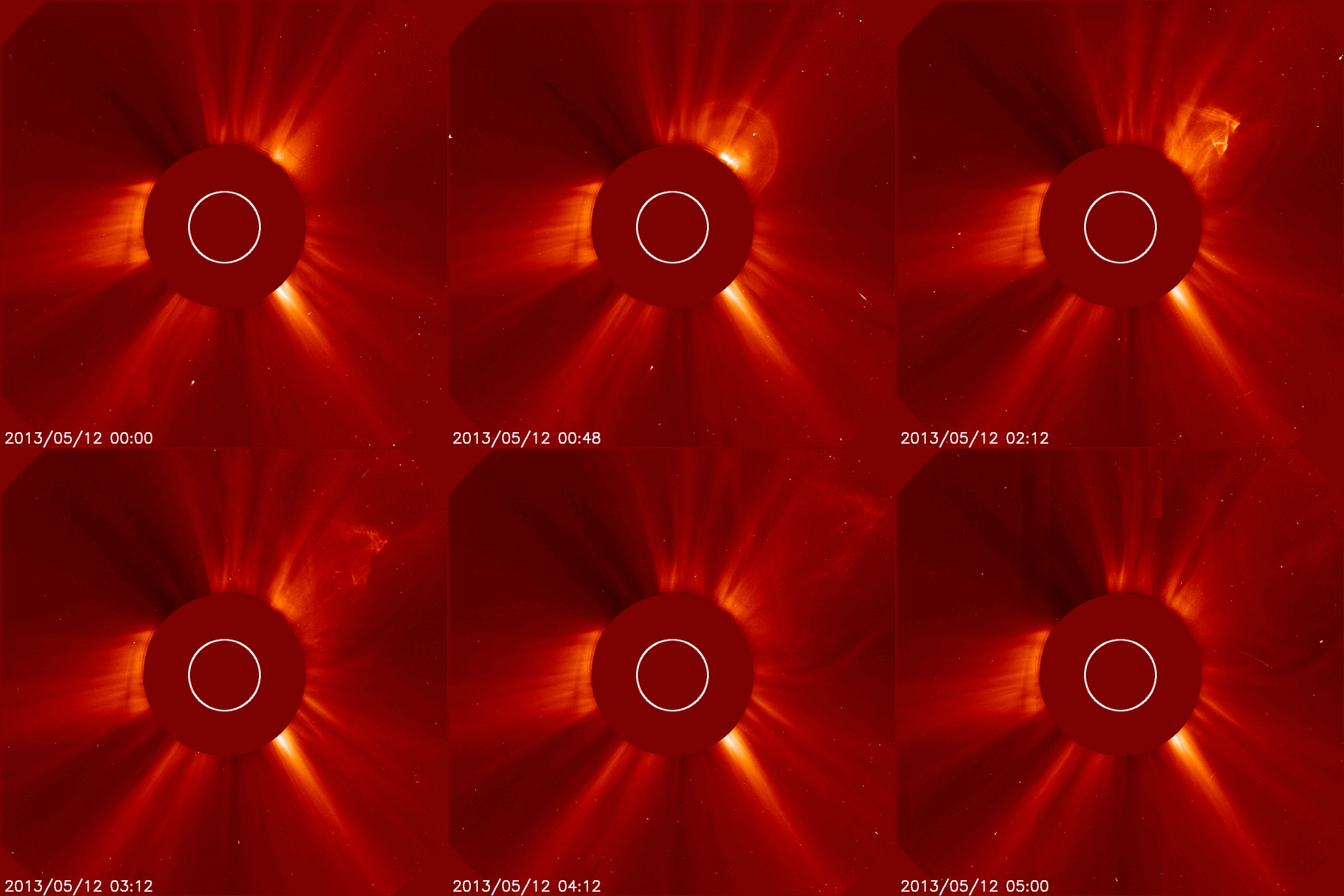
FILAMENT ERUPTION - An unstable filament of magnetism on the Earthside of the sun erupted during the early hours of May 12th. The erupting filament did not spark a significant solar flare (that is, there was no strong flash of X-radiation), but it did hurl part of itself into space. A bright coronal mass ejection (CME) emerged from the blast site andcould deliver a slight, glancing blow to Earth's magnetic field on May 15th.
Video

Sunday, May 12, 2013

Twin cyclones form in the Indian Ocean - Interestingly, one has formed either side of the equator. Each tropical cyclone is spinning in the opposite direction to the other. North of the equator, Tropical Cyclone One is spinning anti-clockwise, whilst south of the equator, Tropical Cyclone Jamala is spinning clockwise. This is due to the Coriolis force – the motion of the earth’s spin, that deflects winds to the right north of the equator and to the left south of the equator.
Tropical Cyclone One - Whilst there is still some uncertainty on this storm’s path, the latest prediction from the Joint Typhoon Warning Center suggests that it will strengthen over the next five days and reach Bagladesh early next week. On making landfall, this storm would bring a significant risk of heavy rain, flooding and damaging winds, with neighbouring Burma feeling its effect too.
Tropical Cyclone Jamala - This storm is going to strengthen over the coming days, but it will stay over open water and poses no threat to land in the foreseeable future. (map)

**HAPPY MOTHER'S DAY!**


LARGEST QUAKES -

Live Seismograms - Worldwide (update every 30 minutes)

This morning -
5.6 SOUTHERN IRAN (also 4.6, 4.4, 3.7, 3.6, 3.6, 4.1, 4.5, 4.5, 4.3)

Yesterday -
5/11/13 -
6.4 TONGA
5.4 ATACAMA, CHILE
5.0 SOUTHERN IRAN
5.0 SOUTHERN IRAN
5.4 SOUTHERN IRAN
6.2 SOUTHERN IRAN (also 3.7, 4.6, 4.6, 4.9, 4.9, 3.5, 3.7, 4.5, 3.6, 4.5, 3.9, 3.9, 3.6, 4.3, 4.6, 4.0, 4.2, 4.3, 4.0, 4.4, 3.9, 4.0, 3.8, 3.8, 4.7, 4.4, 4.7, 4.8, 4.6, 4.1, 4.5, 4.6)

5/10/13 -
5.0 BOUGAINVILLE REGION, P.N.G.
5.1 GUATEMALA
5.3 SOUTHERN MID-ATLANTIC RIDGE
5.4 NORTHEASTERN SAKHA, RUSSIA

2-Year-Old Child Confirmed Dead in Saturday's 6.2 Quake in Southern Iran. 70 villages suffered severe damage in the quake, which was followed by a series of aftershocks. At least 15 people were injured. The quake struck the Arabian Sea port town of Jask at 6:38 a.m. (GMT 2:08 a.m.) Saturday.

VOLCANOES -
Volcano Webcams

TROPICAL STORMS -

In the South Indian Ocean -
Tropical Cyclone Jamala (24s) was located approximately 960 nm east-southeastward of Diego Garcia.

In the Indian Ocean -
Tropical Cyclone Mahasen was located approximately 749 nm southward of Calcutta, India.

Myanmar on alert as cyclone grows - Myanmar (Burma) authorities are on alert as a cyclone threatens to hit the west of the country where around 140,000 people displaced by communal violence languish in flood-prone camps. Meteorologists said it was unclear whether the cyclone would hit Rakhine over the next days or veer further west to neighbouring Bangladesh, but Myanmar's Department of Meteorology and Hydrology said heavy rains and strong winds were likely to batter Rakhine regardless.
The UN's disaster assessment agency later said the cyclone was likely to strike land near Chittagong, in Bangladesh (as a severe cyclonicstorm at about 12:00 GMT on 15 May), but preparations to provide relief in Rakhine were underway. Rakhine, one of Myanmar's poorest and most remote states, is particularly vulnerable to heavy storms, with makeshift camps housing tens of thousands of mainly Rohingya people displaced by an eruption of communal violence last year.
"Many of the camps are located in low-lying coastal areas susceptible to tidal surge." In March the UN warned of "yet another tragedy when the monsoon rains hit (the region)" with displaced people - already short of food, shelter and medicine - having nowhere to go if a storm strikes. Thousands of Rohingya have fled the unrest and insanitary camp conditions in recent months on rickety boats, mostly believed to be heading for Malaysia.
Around 140,000 people died when cyclone Nargis devastated Myanmar's Irrawaddy Delta in May 2008. The cost of repairing the damage was estimated at over four billion dollars.

EXTREME HEAT & DROUGHT / WILDFIRES / CLIMATE CHANGE -

Global carbon dioxide in atmosphere passes milestone level - For the first time in human history, the concentration of climate-warming carbon dioxide in the atmosphere has passed the milestone level of 400 parts per million (ppm).

HEALTH THREATS -

Experts offer dim view of potential vaccine response to H7N9 - If the H7N9 influenza virus now circulating in China evolves into a pandemic strain, the world is likely to have great difficulty providing adequate supplies of an effective vaccine in time to blunt its impact, according to an article by three experts.
Australian test for deadly new bird flu strain - Australian pathologists have modified an existing bird flu test to specifically detect the new strain, H7N9, which has killed at least 32 people.
The steep decline in H7N9 cases in China has influenza experts wondering if poultry market closures have slowed the disease or if the new virus is showing a summerlike decline that other avian flu viruses show.

Count of suspected coronavirus cases in France reaches 3 - A nurse who treated a Frenchman who is sick with a novel coronavirus (nCoV) infection may now have the virus herself, becoming the third person possibly infected in connection with the case.

RECALLS & ALERTS
- Krinos Foods, LLC. of Long Island City, New York is voluntarily recalling its TAHINI sesame paste, because it has the potential to be contaminated with Salmonella.

Friday, May 10, 2013

Gale-force winds set to batter Britain days after sizzling weekend temperatures. Winds of up to 65mph will gust around parts of the country – potentially felling trees and distrupting transport.
After the COLDEST EASTER ON RECORD followed by a sizzling hot Bank Holiday weekend, Britain will now be battered by gales. The Met Office issued yellow warning of severe weather for today for Wales, the Midlands and much of the South, calling on the public to be aware of severe south westerly winds. While the west coast of Britain will see gusts of up to 65mph – speeds classed as a violent storm – gusts of 50mph are expected widely inland.
The gales, with “incredibly strong winds”, are UNUSUAL FOR THIS TIME OF YEAR, forecasters said. The warnings follow the highest temperature of the year of 23.7C being recorded at Crosby, Merseyside Wednesday – signalling the hottest day of the year at the end of a glorious Bank Holiday weekend. But now the entire country faces torrential downpours, grey skies and 70mph gusts.
The storms will reach the western coastal areas by 10am and pass inland to London and the South East by mid afternoon. Average temperatures are expected to hover around 12C, but in the wind it will feel much colder, around 7C. Northern parts of the country will see less winds but the weather will still be blustery and unsettled with frequent showers.
Vantage Weather Services warned of a “vicious” weather system. “We have gone from one extreme to another. We have bounced from spring straight to autumn.” The unsettled weather is set to continue for the foreseeable future.

**The trouble with being punctual
is that nobody’s there to appreciate it.**
Franklin P. Jones


LARGEST QUAKES -

Live Seismograms - Worldwide (update every 30 minutes)

This morning -
None 5.0 or higher.

Yesterday -
5/9/13 -
5.0 HALMAHERA, INDONESIA

China - Over 1100 remain hospitalized after Lushan quake. As of 5 p.m. on Sunday, 5,868 people had been treated and discharged from medical facilities since the quake rocked Lushan County in Sichuan Province on April 20.

Earthquake risk for sale in global markets - The Turkish Natural Disasters Insurance Authority (DASK) has exported a catastrophe bond worth $400 million for a possible Istanbul earthquake.
The initiative marks the first time in its history that Turkey has exported a catastrophe bond. All of $400 million, which had been collected for the catastrophe bond over three years, will be kept at an independent bank account and invested in short-term American treasury bonds. If the expected Istanbul quake happens in three years, DASK will use the money to pay for the damages arising from the quake. If a quake does not happen, the funds will be returned to investors.
“We are providing an additional financial resource to recover the damages from a possible quake in Istanbul by exporting Turkey’s first catastrophe bond, and increasing the DASK’s power of payment to 7.2 billion Turkish Liras.” The Turkish DASK established a company, named Bosphorus 1 Re, in Bermuda to deal with the sales of the catastrophe bond. The company was rated BB+ by Standard & Poor’s. The first price for the catastrophe bond was expected to be $100 million in total.
“We, however, saw demand six times higher than our first expectations, reaching $400 million for three-year catastrophe bonds. What is really something here is that a possible disaster risk in Turkey is introduced to the financial markets. We had seen many storm or quake bonds in the US, bonds for floods or storms in Europe and the bonds for the quakes in Japan for years. Turkey’s first bond for a possible disaster attracted attention mainly from the investors from the US and Europe.”
More than 5.3 million houses are now covered by the compulsory earthquake insurance in Turkey. In other words, 32 percent of 17 million houses in Turkey and 42 percent of the houses in Istanbul are now insured against earthquakes.

VOLCANOES -
Volcano Webcams

Popocatepetl Volcano Eruption Covers Mexican Towns In Ash - The Popocatepetl volcano has spewed ash over several cities in the central Mexico state of Puebla, including the state capital. Mexico's National Disaster Prevention Center says there was an eight-hour period of eruptions at the volcano.

TROPICAL STORMS -

In the Indian Ocean -
Tropical Cyclone Twenty-four was located approximately 805 nm eastward of Diego Garcia.

Cyclone Mahasen (Twenty-four) - With a well-marked low pressure system formed roughly 1,200 km off India's Chennai coast, the predicted Cyclone Mahasen is expected to bring rainfall to Tamil Nadu next week.

HEALTH THREATS -

French health authorities say they fear the country's first case of a new SARS-like virus that has killed 18 people, mostly in Saudi Arabia, may have infected two other people. The 65-year-old man who came back to France from a holiday in Dubai was diagnosed with the deadly novel coronavirus, and is in intensive care in a hospital in the northern city of Douai.
"This is the first and only confirmed case in France to date." But on Thursday the health authorities in the Nord/Pas-de-Calais region said two more people were undergoing tests after showing symptoms of the virus. They were a man who had shared a room in hospital with the patient, and a doctor who treated him.
The unnamed patient, who was in Dubai from April 9 to 17, has been placed in isolation and is being given respiratory assistance and blood transfusions. The virus, known as nCoV-EMC, is a cousin of Severe Acute Respiratory Syndrome (SARS), which triggered a scare 10 years ago when it erupted in east Asia, leaping to humans from animal hosts and killing some 800 people. It was first detected in September 2012 and since then more than 30 cases have been reported in different countries, with 18 deaths.
But the French health ministry says it does not appear to be very contagious. While it has been deadliest in Saudi Arabia, where 11 people have been killed by the virus, other cases have been reported in Jordan, Germany, Britain and now France. The World Health Organisation on Thursday reported two new confirmed cases in Saudi Arabia.

Chinese study finds very few mild H7N9 cases - Testing of more than 20,000 Chinese who had influenza-like illnesses in March and April turned up little evidence of mild cases of H7N9 influenza, as Chinese authorities revealed that another H7N9 patient has died.

Multistate Salmonella outbreak linked to cucumbers grows to 81 cases - Eight more cases of Salmonella Saintpaul infection have been reported in an outbreak linked to imported cucumbers that has now reached 81 cases in 18 states. Although no deaths have been reported, 29% of patients have required hospitalization.
Illness-onset dates range from Jan 12 to Apr 19. Patients range in age from less than 1 to 89 years, with a median of 27, and almost two-thirds are female. On Apr 24 the Food and Drug Administration placed Daniel Cardenas Izabal and Miracle Greenhouse of Culiacan, Mexico, on Import Alert, which means their cucumbers cannot enter the United States unless suppliers verify their lack of contamination. "At this time, there is no indication that contaminated cucumbers supplied by Daniel Cardenas Izabal and Miracle Greenhouse are still on the market." The most-affected states are California, with 28 cases, followed by Arizona with 11 and Minnesota with 9.

Litigation against the UN for Haitian cholera may be ahead (same link as above) - The United Nations has been challenged to agree within 60 days to compensate Haitians sickened with cholera since 2010, to apologize to the country for introducing the disease within its borders, and to launch a major sanitation-improvement effort or else face a lawsuit. The human rights group Institute for Justice and Democracy in Haiti announced the action in response to a February letter from the UN saying it was not responsible for the cholera outbreak and asserting its legal immunity. Cholera broke out in Haiti beginning in October 2010 and has affected nearly half a million people, killing about 8,000.
The origin of the cholera-causing bacteria is thought to be contamination of a river from sewage pumped directly into it from a UN-sponsored base which housed peacekeeping workers from Nepal. Previously, Haiti had not had a cholera problem since the 1880s. Lawyers for the institute, who say they have 8,000 people ready to join the suit, plan on suing in New York state court and perhaps in a European venue as well; they are seeking $100,000 for each family who lost a member to cholera and $50,000 for each cholera survivor.